
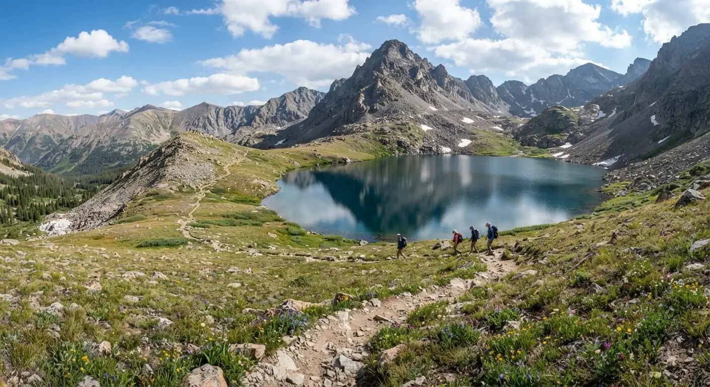
If you love alpine lakes, mountain views, and peaceful hiking trails, the Ptarmigan Lake hike near Buena Vista, Colorado, deserves a place on your adventure list. Located in the beautiful San Isabel National Forest, this scenic trail takes you through forested paths, rocky sections, open meadows, and stunning mountain scenery before reaching the lake. The Ptarmigan Lake Trail is a rewarding day hike, but its steady climb and high elevation make it more challenging than a casual walk. Before you go, it helps to understand the trail distance, elevation gain, hiking time, and difficulty. This guide covers everything you need to plan your trip, including directions, parking, the best time to visit, essential gear, and safety tips for enjoying this beautiful hiking destination near Buena Vista.
Quick Answer
The Ptarmigan Lake hike near Buena Vista, Colorado, is a scenic mountain trail in the San Isabel National Forest. Expect around 6–7 miles round trip, with roughly 1,400–1,600 feet of elevation gain, depending on your route. Most hikers need about 3–4 hours to complete the hike. The trail includes forest paths, rocky terrain, and steep sections. July through September is generally the best time to visit, depending on snow and weather conditions.
Where Is Ptarmigan Lake in Colorado?
Ptarmigan Lake is located in central Colorado, near Buena Vista, in the beautiful San Isabel National Forest. The lake sits high in the mountains near the Sawatch Range, where hikers can enjoy alpine scenery, rocky slopes, and wide views of surrounding peaks. It is a popular destination for people exploring the outdoors around Buena Vista and the Arkansas River Valley.
The trailhead is reached from Cottonwood Pass Road, also known as County Road 306. From Buena Vista, the drive takes you west toward the mountains and the Cottonwood Pass area. The route offers lovely views, especially during summer and early fall.
Because the lake sits above 12,000 feet, the hike feels different from a low-elevation walk. Plan extra time, check the weather, and allow your body to adjust to the altitude before starting.
Ptarmigan Lake Trail Distance, Elevation Gain, and Difficulty
The Ptarmigan Lake Trail is generally around 6–7 miles round trip, depending on the route and where you turn around. Many hiking guides report approximately 1,400–1,600 feet of elevation gain, making this a moderate to challenging mountain hike. Exact figures can vary with the mapped route, GPS readings, and chosen endpoint.
The trail climbs from a high-elevation starting point through forest, rocky areas, and open mountain terrain. Some sections are steep, uneven, or tiring, especially as the air gets thinner. You do not need technical climbing skills for the usual hiking route, but good balance and a reasonable level of fitness will help.
Most hikers should plan for 3–4 hours, with extra time for breaks, photos, and enjoying the lake. If you are new to high-altitude hiking, start slowly and be ready to turn around if you feel unwell.
How to Get to the Ptarmigan Lake Trailhead
To reach the Ptarmigan Lake trailhead from Buena Vista, follow County Road 306 toward Cottonwood Pass. The drive takes you into the mountains west of town. Use a current map or navigation app to find the trailhead, and download the route before leaving because mobile service may be unreliable in the area.
Road and trail conditions can change with the season. Before driving, check for closures, construction, and weather updates. The final approach may include mountain-road conditions that require careful driving, particularly after rain or early-season snow.
Parking at the trailhead is limited, so arriving early is a good idea, especially on summer weekends. Park only in marked or clearly permitted spaces, and never block the road or access for emergency vehicles. Bring drinking water with you because you should not expect reliable drinking-water facilities at the trailhead. Plan your drive and hike before setting out.
What to Expect on the Ptarmigan Lake Hike
The Ptarmigan Lake hike offers a mix of forest scenery, rocky mountain paths, small bodies of water, and beautiful alpine views. The trail climbs steadily, so the effort increases as you gain elevation. Conditions underfoot can change throughout the route, from soft forest ground to loose rocks and uneven sections.
Starting the Hike Through the Forest
The hike begins with a walk through mountain forest, where trees provide some shade and the trail gradually gains height. Take your time during this first section instead of starting too quickly. The altitude can make even a gentle climb feel harder than expected. Watch for roots, rocks, and muddy patches, especially after rain or snowmelt. The forest is a lovely place to enjoy the fresh mountain air, but remember that the trail continues uphill. Keep drinking water, take short breaks when needed, and save some energy for the higher sections. Wearing comfortable hiking shoes or boots will help you handle uneven ground. As the trees become less dense, you may begin to see more of the surrounding mountains.
Navigating Rocky Sections and Smaller Lakes
Farther along, the trail becomes more rocky and uneven, with steeper stretches that require careful footing. Depending on the route and seasonal conditions, you may pass small ponds or lower water features before reaching the main lake. Do not assume that every body of water along the way is Ptarmigan Lake. Use a reliable offline map to confirm your location, especially where the trail becomes less obvious. Snowmelt can create wet areas or small stream crossings, so slow down and choose secure footing. Avoid stepping on loose rocks that could shift beneath you. If the path is covered by snow or difficult to follow, do not guess your way forward. Turn around if you cannot safely identify the route.
Reaching Ptarmigan Lake and Enjoying the Views
Reaching Ptarmigan Lake is the highlight of the hike. The alpine setting, clear water, rocky mountain slopes, and surrounding peaks create a beautiful place to rest and take photographs. The landscape changes with the season, and summer wildflowers may add color to the open areas. Find a safe place to take a break without damaging plants or walking across fragile shoreline areas. The lake is high in the mountains, so temperatures can be cooler and winds stronger than they were at the trailhead. Bring an extra layer, even on a sunny day. Remember that reaching the lake is only halfway if you plan to return by the same route. Leave enough daylight and energy for the descent, and pack out everything you bring.
Is Ptarmigan Lake Trail Good for Beginners?
The Ptarmigan Lake Trail may suit active beginners who are comfortable walking several miles and climbing uphill, but it is not an easy first hike for everyone. Its distance, steady elevation gain, rocky terrain, and high altitude can make it challenging. Even hikers who are fit at lower elevations may need more time and frequent breaks in the mountains.
If this is your first Colorado mountain hike, consider starting with a shorter, lower-elevation trail to see how your body responds. If you decide to hike Ptarmigan Lake, begin early, walk at a steady pace, and carry enough water, food, and warm clothing. Check the forecast and trail conditions before leaving.
Do not feel that you must reach the lake. Turning around is a sensible choice if you feel exhausted, the weather changes, or the trail becomes unsafe. Enjoying the outdoors safely matters more than completing the route.
Best Time to Hike Ptarmigan Lake
For most hikers, July through September is the best general window for the Ptarmigan Lake hike. Summer often brings more accessible trails, green mountain scenery, and seasonal wildflowers. However, snow can remain on high sections into early summer, and wet ground or snowmelt may make some areas harder to cross.
July and August are popular months for mountain hiking, but afternoon thunderstorms are a serious concern in Colorado. Start early and aim to leave exposed areas before storms build. September can bring cooler air and beautiful fall colors, although conditions may change quickly as the season progresses.
Hiking in October may be possible in some years, but snow, ice, freezing temperatures, and shorter daylight hours can make the route more difficult. Check recent trail reports and the local forecast rather than relying on the calendar alone. If snow covers the trail or conditions exceed your experience, choose a safer route or postpone the hike.
What to Pack for the Ptarmigan Lake Hike
Packing the right gear helps make the Ptarmigan Lake hike more comfortable and safer. Start with sturdy hiking shoes or boots that provide good grip on uneven, rocky ground. Carry enough water for the full outing, along with snacks or a packed lunch to keep your energy up. A small first-aid kit, sun protection, and an offline map are also useful.
Mountain weather can change quickly, even during summer. Pack layers of clothing, including a warm mid-layer and a waterproof rain jacket. A hat and sunglasses can help protect you from strong sunlight at high elevation. Trekking poles may be useful on steep or rocky sections, particularly during the descent.
Before leaving, check that your phone is charged and your route is saved for offline use. Pack a headlamp in case the hike takes longer than planned. Carry out all rubbish, and bring a bag for waste so you leave the trail clean.
High-Altitude Hiking Safety and Weather Tips
The Ptarmigan Lake hike reaches high elevation, where the air contains less available oxygen than it does at lower elevations. You may feel tired, breathless, or develop a headache more quickly than expected. Walk slowly, take breaks, and give yourself time to adjust if you have recently arrived in Colorado. Fitness alone does not prevent altitude-related illness.
Drink water regularly, eat snacks, and wear layers to handle changing temperatures. Check the forecast before you leave, and watch for dark clouds, rising winds, thunder, or lightning. Colorado storms can develop quickly, particularly during summer afternoons. Avoid exposed ridges and open areas when storms threaten, and do not wait for lightning to get close before making a safe plan.
Know when to turn around. If you develop a headache with nausea, dizziness, or unusual weakness, stop and assess your condition. Severe or worsening symptoms require descending and seeking medical help. Confusion, trouble walking, or serious breathing difficulty are emergencies. Never push on just to reach the lake.
Dogs, Fishing, and Camping Near Ptarmigan Lake
Outdoor activities around Ptarmigan Lake may appeal to hikers who want more than a day walk, but rules and conditions can vary. If you plan to bring a dog, check the current regulations for the trail and surrounding public land before your trip. Keep your dog under control, carry waste bags, and bring enough water for both of you. Rocky terrain, cold water, and high altitude can be tiring for pets, too.
Anglers should confirm current fishing rules, including license requirements, permitted methods, and any local restrictions. Do not assume that fishing is allowed simply because a lake is accessible. Check Colorado’s current fishing regulations before packing your gear.
If you are interested in camping or backpacking, research the rules for the specific area first. Not every lakeshore or open spot is a legal campsite, and fragile alpine ground can be easily damaged. Follow posted restrictions, use established sites where permitted, and practice Leave No Trace principles. Keep wildlife wild and take all rubbish with you.
Parking, Crowds, and Trail Etiquette
Parking at the Ptarmigan Lake trailhead is limited, and the area can become busy during summer weekends and popular hiking periods. Arriving early gives you a better chance of finding a permitted space and allows more time to complete the hike before afternoon weather develops. Never park in a way that blocks traffic, private property, or emergency access. If the parking area is full, do not create a dangerous roadside spot.
Help protect the trail by staying on the established route instead of cutting across meadows or fragile plants. Give uphill hikers room where possible, and step aside safely to let others pass. Keep noise low so everyone can enjoy the mountain setting. If you hike with a dog, follow local leash rules and prevent it from chasing wildlife.
Carry out food wrappers, tissues, and other rubbish, even if bins are available near the trailhead. Avoid disturbing animals, picking wildflowers, or moving natural objects. Good trail etiquette helps keep this beautiful Colorado hiking destination enjoyable for future visitors.
What to Know Before Your Hike: Trail Conditions and Navigation
Before setting out, check the latest Ptarmigan Lake trail conditions. Snow, mud, fallen trees, stream crossings, and weather can change how difficult the route feels. An online guide may describe typical conditions, but it cannot guarantee what you will find on the day of your hike. Recent reports, local land-management updates, and the weather forecast are more useful for making a final decision.
Download an offline trail map before leaving Buena Vista because cell service may be weak or unavailable in the mountains. Keep track of your location as you hike, especially around rocky areas and smaller lakes where the route may be less clear. Bring a charged phone and a backup way to navigate if possible.
Start early enough to return before dark, and tell someone your plan and expected return time. If snow hides the trail, storms approach, or you lose the route, stop and reassess. Turning back is always better than taking an unsafe risk.
Is the Ptarmigan Lake Hike Worth It?
The Ptarmigan Lake hike near Buena Vista, Colorado, is worth considering if you enjoy mountain scenery and do not mind a steady uphill climb. The route offers forest trails, rocky terrain, alpine views, and a beautiful lake at the end. It is a rewarding way to experience the high country of the San Isabel National Forest without needing technical climbing skills on the usual hiking route.
However, this is not a casual stroll. The distance, elevation gain, changing weather, and high-altitude setting mean you should prepare carefully. Hikers who are new to the area should be honest about their fitness and experience, and they should not feel pressured to finish the route.
For the best experience, visit during a suitable weather window, start early, carry enough water and layers, and check current conditions. With thoughtful planning and respect for the landscape, Ptarmigan Lake can be a memorable Colorado hiking adventure.
Frequently Asked Question’s
How long is the Ptarmigan Lake hike?
The hike is generally around 6–7 miles round trip, depending on your route and endpoint. Check a current trail map before setting out, as distances can vary between guides and GPS tracks.
How difficult is the Ptarmigan Lake Trail?
It is usually considered a moderate to challenging hike because of the uphill climb, rocky ground, and high elevation. Beginners should be prepared for a slower pace and should turn back if conditions feel unsafe.
How long does it take to hike Ptarmigan Lake?
Most hikers should allow about 3–4 hours, with additional time for breaks, photos, and changing trail conditions. Your pace, fitness, weather, and time spent at the lake can affect the total.
Where do you park for Ptarmigan Lake Trail?
Parking is available near the trailhead along the Cottonwood Pass Road area, accessed from County Road 306. Spaces can be limited, so arrive early and park only where permitted.
Can you hike Ptarmigan Lake in October?
Possibly, depending on the year and current conditions. Snow, ice, cold temperatures, and short daylight hours can make the hike more difficult. Check recent reports and forecasts before deciding to go.
Are dogs allowed on the Ptarmigan Lake Trail?
Rules can vary by land-management area and may change. Check current local regulations before bringing your dog. Carry water and waste bags, follow leash requirements, and consider the effects of altitude and rough terrain on your pet.
Can you fish at Ptarmigan Lake?
Fishing access and rules should be confirmed before your trip. Check current Colorado fishing regulations, license requirements, and any local restrictions rather than assuming fishing is permitted.
Is Ptarmigan Lake Trail good for beginners?
It can suit active beginners with good preparation, but it may be demanding for someone new to hiking. The high elevation, rocky trail, and steady climb make it important to start slowly and be willing to turn around.
Final Thoughts
The Ptarmigan Lake hike near Buena Vista offers a wonderful chance to enjoy Colorado’s alpine scenery, mountain air, and peaceful lake views. With a little planning, the trail can become a rewarding day outdoors. Check conditions, prepare for the altitude, start early, and leave enough time for your return. Most importantly, respect your limits and protect the natural landscape so others can enjoy it, too.